
(The OC redistricting might end up as a big battleground. A map I’ve seen floating around has Loretta Sanchez’s district split up into three. As Seneca Doane points out, there are a lot of Voting Rights Act issues at stake here. – promoted by Brian Leubitz)
 In Orange County, over the last few days, we’ve been talking a lot about the Latino vote, which has not been well-served by the Congressional maps recently proposed by the California’s Citizen Redistricting Commission late last week. In this diary, I present an alternative proposal — one that I presented to the Commission but intentionally did not present here or in any other partisan venue — that I think does a better job of protecting the Latino vote.
Lest I be seen as slagging the Commission, I will say that the Assembly and Senate maps do a better job of ensuring a large Latino voice in a reasonable number of Orange County districts, and that in other respects their Congressional Map seems quite reasonable. If the “joining Santa Ana to Newport Beach” problem is resolved, I think that they will be better than what we’ve had — although that opinion is certainly open to revision. They are certainly less ugly — more compact and less obviously gerrymandered. I think that that’s what supporters of the Commission wanted.
One preliminary point: neither I nor anyone to whom I’ve spoken about them was clear on who exactly authorized them and whether these maps have even preliminary support by the required 3 (of 5) Democrats, 3 (of 5) Republicans, and 3 (of 4) Others.
1. What I did in the Redistricting Wars
What I decided to do — and why I did not end up playing a lot with people on “Son of Swing State” — is to follow both the letter and spirit of the law as established in the initiatives on redistricting. That means: (1) I did not take any note of where any incumbents or potential candidates lived, (2) I did not take note of which districts were better or worse for Democrats — or even what the political composition and specific voting record of each district was, (3) I gave substantial weight to compactness and honoring city and county lines — and even more so to equal population and (4) I gave even more weight to honoring “communities of interest.” The problem is that it’s not really clear what “communities of interest” are — and how common they are. I considered race, ethnicity, socio-economic status, ease of mutual access, and some aspects of topography (proximity to the ocean, hills vs. flatlands) to be communities of interest. In most cases, though, they did not exceed the importance of the most obvious community of interest: living in the same community. In other words, to me sharing a city and county is something that people understand and appreciate as a “not-a-gerrymander,” and it’s probably more important to people that knowing that two neighboring cities across county lines each have 25% of an ethnic minority group and should therefore drag a district — dragging the other 75% of the district behind them.
I had redistricted most of the state using the “We Draw the Lines” software from the Commission’s partner site healthycity.org — I could never get Microsoft Silverlight-requiring Dave’s Redistricting App to run on my computer — before at some point my heretofore-never-overtaxed old desktop computer could handle it absolutely no longer. It was taking me about an hour to make small changes — and I couldn’t even get maps to print out. Luckily for me, the redistricting I did was so simple that it could almost entirely be described with a list of cities and counties. I never quite finished the statewide Congressional districting, and never even got started on state legislative districts, but I did finish maps for Orange County, where I live. (I also did Board of Equalization districts, splitting only LA, San Bernardino and Solano counties.) Sadly for me, the maps were scrubbed sometime a week or less before the maps were released, saving me a lot of time doing screen captures but also some frustration at literally a week or more of effort wasted. Oh well, some art isn’t meant to last!
2. The Santa Ana problem
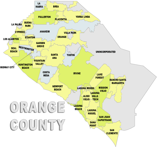
This is probably a good place to introduce readers to the geography of Orange County. Here’s a map that has nothing to do with any redistricting proposal, theirs, mine, or otherwise:

The center of Orange County’s Latino community is the county seat of Santa Ana. A city of almost 400,000, it is the densest city of 50,000 people or more in the U.S, about 50% denser than New York City. According to the 2010 Census (almost surely an undercount), it is about 78% Latino, 90% of that being Mexican.
Santa Ana’s almost-neighbor to the north, Anaheim, is a city of about 336,000 that is 53% Latino. The figure is misleading, however. Anaheim Hills, roughly the part of Anaheim east of the Costa Mesa Freeway (SR-55), is quite wealthy and not heavily Latino. While Anaheim has a lively mix of ethnicities, the portions nearest Santa Ana are more than 53% Hispanic.
Santa Ana and Anaheim don’t quite share a border, being separated by a southwestern tendril of the city of Orange, which is northeast of Santa Ana and southeast of the western bulk of Anaheim. It too is bisected vertically by the Costa Mesa Freeway, but with much left to the west of it. That section to the west, though, fits pretty well with Anaheim and Santa Ana, and so far as I can tell has a disproportionate number of Orange’s 38% Latino population (up, by the way, from 10% in 2000.)
Santa Ana has been tied to Garden Grove, with its burgeoning Vietnamese population (which, along with that of neighboring Westminster and the nearest parts of Santa Ana, does form a true community of interest. CA-47, which has been 65% Latino, has been represented by Loretta Sanchez; last year, the most prominent Vietnamese politician in California, Van Tran, ran against her and (backed by Meg Whitman’s MegaBucks) seemingly pushed her to the brink before she eventually pulled out a solid low-double-digit victory. Sanchez’s (and Tran’s) vote totals were very low, though, which may be attributable to some or all (or none) of factors such as the negative campaigns in the race, its being an off-year election, and Latinos simply voting at lower rates compared to the broader population.
In its Santa Ana meeting, the Redistricting Commission was asked by many people to keep Garden Grove with Westminster and separate both from Santa Ana, in part to allow the Vietnamese community to develop its future political influence. To its credit, the CRC did so. But it did it in almost the weirdest way possible. Rather than connect Santa Ana to the largely Latino areas of Anaheim and Orange, among other options, the CRC connected it to the overwhelmingly Republican coast — most starkly (and hilariously for OC residents) to wealthy Newport Beach. Here’s the CRC’s draft map:

Note: that lavender-colored line at the bottom is the approximate county line dividing the district that extends into San Diego. The top of the map (above La Habra) is OC’s northern border. The city of La Palma is also not shown in this map, being absorbed into L.A. County. The labels contain the working name for each district, the deviation from perfect equal district representation in raw number and percentage terms, and then the percentage of each district of, respectively, Latinos, Blacks, and Asians.
If you look at that coral-colored district, which travels down the coastline taking up most of the Orange County portion of Dana Rohrabacher’s horrifically gerrymandered CA-46 (that went for miles, through a skinny section of Long Beach, to the Palos Verdes peninsula) and then to CA-48, currently represented by John Campbell. Then it bulges in from the coast to take in part of CA-47 — specifically, Santa Ana. (Either the CRC really didn’t look at incumbent residences or they have an excellent sense of humor for putting Loretta Sanchez, Dana Rohrabacher, and John Campbell into the same district. It’s almost admirable.)
Newport Beach is the eighth-most expensive housing market in the U.S. It’s a little under 5% Latino. The ratio of registered Republicans to Democrats is a shade over 2.5 to 1. With a population of about 86,000, it’s about 1/4 the size of Santa Ana. If you look at the [2010 election results], however, you’ll notice a difference in voter turnout. Here’s a sample: in Santa Ana’s pretty competitive Mayoral election, about 42,000 people came out to vote. In Newport Beach, 30,000 people voted on “Amendment V – Newport Beach, Charter Amendments and Ordinance Repeals” alone. Putting Santa Ana and Newport Beach in the same district all by themselves is a pretty even fight.
Now add conservative-leaning Costa Mesa, Huntington Beach, and Seal Beach into the same district, and it becomes clear that Santa Ana would not be represented by a Latino in Congress for the next decade. And, in fact, by dividing up the Latino concentration in central Orange County — and not even connecting it to the Latino concentration in Northwest Orange County, in areas such as Buena Park — the Congressional map likely means no Latino Congressional representation from anywhere in Orange County for the next decade. (The north, northwest, and coastal districts have respectively about 23.5%, 22.5%, and 22.5 Latino population.)
It’s not that hard to combine much of the Latino area in one district with a similar proportion to what CA-47 has now, without using it as a way to snuff out the neighboring Vietnamese community. That’s what I propose to do.
3. My proposal
My proposal for Congressional districting in Orange County is below. I can’t provide the percentages because the software recommended by the Commission no longer works at all (at least on my computer) and as noted above I can’t get “Dave’s App” to run, but if anyone wants to calculate the percentages it’s pretty easy. My recollection is that the Latino portion of the district containing Santa Ana is about 65% — almost exactly what CA-47 has been now — and that’s the main fix needed for the Commission’s proposals. Other parts of the map overlap with much (although obviously not all) of the work they did.

As you can see, four cities are divided, all by SR-55 (the Costa Mesa freeway), which is a fair boundary within the central county between the more and less pricey parts of town. (Anaheim, Orange, and Costa Mesa are obvious; perhaps less obvious is Santa Ana, which includes that mess of lines in blue at the top of what looks like Newport Beach and allows Santa Ana to take in the airport and a neighboring area that is almost entirely detached.)
My proposed CA-47, the Latino-majority district, is in yellow. My proposed CA-40, in which Vietnamese voters may develop as a voting bloc without being stifled by the Latino majority in the current CA-47, is in green. Curving around proposed CA-47 (but still quite well accessible end-to-end by freeway) in pink is CA-42. Newport Beach, Irvine, and most of south county are in proposed CA-48, represented in blue. Orange County has to share at least one district with another county — I chose to put the southernmost cities in South County into a district with northwest San Diego county. (It’s not shown, but for the record you fill up a Congressional District quite nicely by including Pendleton/San Onofre, Oceanside, Fallbrook, Carlsbad, Vista; but not Encinitas, Escondido, San Marcos.)
I think that this has the advantages — primarily allowing clear understanding that this is not a political gerrymander — over the Commission’s map without dividing up and neutralizing the representation of OC’s Latino voters in Congress.
I would just as soon not know the partisan breakdown of my proposed districts or who lives where. Following the rules of the Commission and the will of the voters as I understand it, I didn’t take them into consideration. This might disadvantage one or the other party, but I doubt it. To me, it looks like it’s about as competitive as one is going to get without a partisan gerrymander.